Thursday, September 15, 2011

North Bass Trail


Headed out to Swamp Point yet again.. this time to do the North Bass Trail. Happened upon three days off with Jesse for the first time since June so we ditched our Wave permit and decided to go backpacking.

Lots of creek walking and boulder-hopping so the hike took much longer than expected to get down. We had just gotten to the Tonto by noon when it was getting pretty hot.
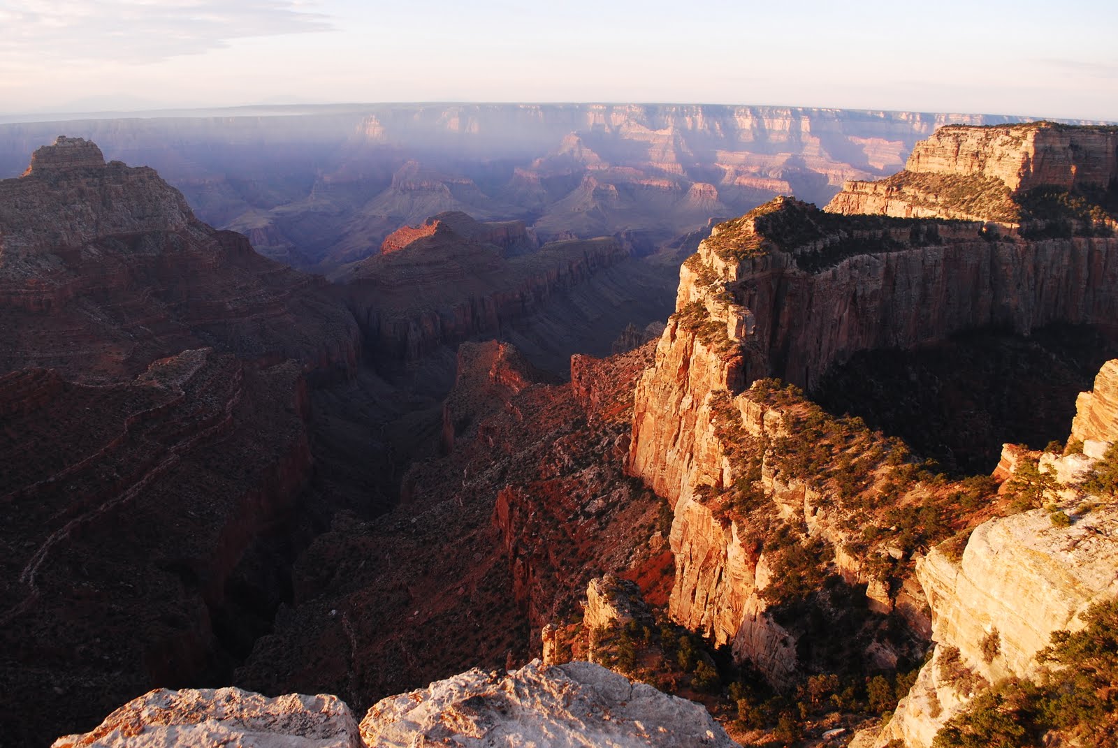
Luckily the clouds rolled in and we had some nice cloud cover for the last stretch of descent through the Tapeats Sandstone down to the creek.

First view of Shimumo creek.. glorious! You can hear it pretty clearly from up there and all you want to do is run down to it and get wet.
Ended up lounging by the creek for a while.. napping, snacking and cooling off. Not much else to do in the middle of the day down at the bottom.


Our campsite on right. Set up camp and our little tarp/tent just before the rain rolled in. It stopped long enough for us to venture out, make dinner and watch the bats, birds, and dragonflies feast on all the mosquitos (really cool)... But then the storm continued most of the night.

Ronnie Dean... The rattlesnake that hung out at the edge of our camp for most of the night and morning. Named him after Ron from GCA and the story he told about a young woman naming her newborn child after him when he "helped deliver it"... An extreme exaggeration he told some fellow deputies after they gave him crap for delivering a baby hahaha.

Headed down to the river and ran into some fish biologists on a Humpback Chub trip. They told us to go down to the river and eat some trout... so we did. Stopped to check out Bass's camp for a moment as well.


View from a little terrace we had to climb up to before we descended to the river.

Made it to the NPS camp to find none other than our river ranger friend manning the place (lounging in the shade reading a book). So we chilled on the beach, ate trout, chatted... and then he lead us downstream back to Shinumo Creek where we jumped off a little pouroff into a pool. FUN! Although the climb back up was a bit ridiculous so we only did it once.

Got poured on on the way back which was refreshing... and made for a beautiful double rainbow upon our return to camp.


Next day made breakfast and headed back up via White Creek. More creek walking and boulder hopping. Twas a bit tough and time consuming.


Made it to the slotty canyon part and out just as it started raining.. Perfect timing!


Huge boulder at the top of the canyon... just another reminder of how scary flash floods are! That thing was about the size of a smart car haha.
Slowly but surely continued the hike out. Got clouded out and rained on which was perfect! Made for a much cooler, more comfortable hike... And listening to Thunder booming and echoing throughout the canyon is amazing.


Finally made it up to Swamp point around 6pm. It was cold up here! But beautiful. Turned out to be a pretty perfect hike.. good weather, smoked trout, cool rocks and scenery... can't beat it.

Friday, September 9, 2011

Cape Royal Sunrise


Had my friends up to the North Rim last weekend... they left Monday morning around 5am... and Jess and I figured since we probably wouldn't be awake that early for a while, we would take advantage and head out to Cape Royal for our first Cape Royal sunrise.

Picture on Left is our little stretch of Colorado River from Cape Royal. I have a sneaky feeling that most people don't even see it when they go there (on account of all the people that ask me where it is when I'm roving at the point).


Wotan's trone in the early dawn light. The sunrise was beautiful but I must say the coolest thing I saw was a Perigrine Falcon going after a bat in the air right above me and then briefly landing on the railing about 8 feet in front of me. So brief that I didn't even have time to think about grabbing my camera. Was still in shock a few seconds after he flew away.


Freya castle and I believe Apollo and Venus temples in the distance. Forgot who's responsible for the Germanic/Norse names but I believe Freya was the goddess who transported souls that died in Wotan's service to the Walhalla (Norse heaven). Some mythology for you.
You can sort of make out Jesse standing at a little overhang taking pictures on the left.

Got out to Jesse's overhang too. View of Wotan's throne and Vishnu temple from there. Quite lovely.

Powell Plateau

Apologies for the delay... haven't been taking too many pictures and thus not having anything terribly exciting to display on here. Going to backtrack a bit. The weekend before last, I only had one day off... So Jesse and I headed to Swamp point after I was done work. A huge thunderstorm was raging just as we were leaving and we stopped in the meadows to watch the lightning... Made it out near the point and slept in the truck while the storm was raging around us. Intense!

A stormy night made for a beautiful morning out on the point.
Our plan was to hike up to Powell Plateau and Dutton Point. All the points on the plateau are named after the early geologists and surveyers of the Grand Canyon area. Dutton is a lot of people's favorite. He's responsible for all the Eastern names and some of the most beautiful scientific writing to describe the Geology of the Southwest.


Stopped to admire all the fossils (on right). Huge slabs (called fossil hashes) covered in crinoids, sponges, bryozoans, corals... So cool!


Also stopped to check out "Teddy's Cabin".. named because Teddy Roosevelt slept in that area when he went mountain lion hunting on the Powell Plateau but the cabin wasn't built until a few years later. Still a neat spot though. Apparently it has been a refuge for tired hikers for a very long time (There was a log in there that we browsed through and added to).

Came across lots of ruins and pottery shards. Picture on right is a nice big corrugated piece. There were tons of them! Lots of Lithics too. Supposedly there are metates (rock slabs for corn grinding) as well but we didn't come across any in our 7 mile stretch.


Stopped and had a snack on this huge ponderosa pine tree- Jesse for scale. Possibly the largest ponderosa I've seen here.


The trail ended but the beefalo have done an excellent job of creating their own trails so we didn't have much touble going the extra un-trailed stretch to Dutton Point.
It was beautiful! Big stretch of river, huge open canyon... lovely view.


Coming back up from the saddle at 2pm in direct sunlight was pretty tough... and hot! The only time I can think of when I actually asked Jesse to spit water in my face. Nice day though.

Sunday, July 24, 2011

Cedar Breaks


Left the crowds at Bryce and headed south to Cedar Breaks. I've decided it is the North Rim version of Bryce.. similar looking formations, but higher up, colder, less crowded, and beautiful meadows on the drive in. Quite a breath of fresh air after hot croweded Bryce Canyon. Went during the Wildflower festival- although many of the flowers weren't blooming just yet.


Left the monument and went further up the road into the forest and up to Brianhead... elevation around 11,300 ft... It was quite frigid.


So high up that the road was still snowed in so we had to park the subey and walk up most of the way. Up on top there is a church-looking structure built by the CCC... lots of marmots too.


One of my two yellow-bellied marmot friends that we met up there... he seemed pretty confused about our presence. Seems as though not too many people make it up that way.

Overall.. a pretty big fan of Cedar Breaks. Thinking about heading back up for some Shakespeare and mountain biking... good chance of the altitude killing me if we do so up at the top though... we'll see.

Friday, July 22, 2011

Bryce

Rolled into Bryce one Sunday afternoon.. Decided to drive past the crowds and down South to Rainbow Point. Took a little stroll down the bristlecone pine loop... Bristlecones may be tied with aspens for my favorite tree position.. Also called wind timber, they only grow on the edges of cliffs and rims where the conditions are the worst they could be.. windy, exposed, dry, rocky soils... hardcore. But they are some of the oldest living things around.


One of the oldest bristlecones at Bryce... about 1700 years old. Looks dead, and it might be but it'll be kmpossible to tell while theres still at least 10 inches of bark on the tree. Probably started going down the tubes when they told everyone how old it is and people started touching it, taking pieces of it... etc.
There is a bristlecone in the White Mountains in California, Methuselah, that is almost 5,000 years old!


There were some cool youngins on the trail as well. The needles are so soft! Hard not to caress them for a little while.

A little further down the trail is a small structure with a couple plaques with some Thoreau quotes on them.. Like this one:
"I need solitude. I have come forth to this hill... to see the forms of the mountains on the horizon- to behold and commune with something grander than man."


It started getting dark (and cold) so we started driving back. Stopped at natural arch on the way. Did a lightening speed Ed Abbey-style tour... driving real fast, jumping out of the car, leaving it running and trying to take in the views in less than 14 seconds. Kind of fun.

Managed to get a pretty balla spot in the campground.. Not really our style- had to pay about 15 bucks but we weren't really fancing wondering around Dixie national foerest in the dark trying to find a spot.


Got up early and started hiking with some nice cloud cover. Had a pretty ambitious hike planned out but (Jesse) ended up getting bored and cutting it short. Hiked from Bryce point, down through the canyon and up to sunrise point, then took the rim trail back. Must say it is kind of nice hiking in a canyon without putting a ton of effort in (like here).


By the time we finished, it was sunny and beautiful- also hot and crowded.. So we were pretty anxious to get out of there.

Thursday, July 14, 2011

Old Bright Angel Trail


Last weekend, Jesse and I headed back into the canyon... This time on the Old Bright Angel Trail- the trail that was used for getting across before the CCC made the North Kaibab Trail all nice. Parked the suby off the scenic drive and had a nice morning stroll through the forest before getting to the trailhead.

View a little ways down... The trail wasn't as bad as many people said.. And we were shaded for the first half.
Early morning view of bright angel canyon on left.


Mystery poo... anyone know what this is? Might have to refer to "Who pooped in the park"- an excellent resource for identifying animal poopies.


Made it down to the Waterslides in Bright Angel Creek (left)... With somewhat ominous rainclouds in the distance. We only got a few drops but the clouds and winds cooled everything down significantly.. not your average scorching hot july day down in the canyon.


Little King snake we ran into around mossy cove. He let us take a few pictures of him and then continued on his way over the ledge.

Overall a pleasant day hike... it really makes all the difference having the trail to yourself... me like

Monday, July 4, 2011

Kolob Canyons/ Buckskin Gulch

Happy Fourth! Celebrating sans fireworks today.. extreme fire danger up here on the Kaibab plateau... not that we're allowed to have fireworkds when fire danger isn't extreme but that's ok. NPS and Forever Resorts usually celebrate with a water fight but I think they've scaled that back too. I just want to eat barbequed goodness and play some volleyball...


Anyway... still behind. A few weeks ago Jesse and I had a permit to hike Buckskin gulch over two days and stay overnight. However, with the slight chance of rain and Buckskin being one of the slottiest slot canyons around, we decided not ot risk it. Headed up to Kolob in Zion instead (sort of like the North Rim of Zion... less people, no shuttles, more remote, a bit smaller but still cool).


Did the Taylor Creek Trail, a delightful little hike along Taylor Creek that takes you to Double Arch Alcove. We got caught in a rainstorm about a half mile from the alcove and had to hover under a little overhang along the creek because we came ill-prepared without rain jackets. After about 20 minutes it cleared up and we got to the Alcove; two huge arches right on top of each other. Pretty cool.


Finished the hike and headed up to the end of the scenic drive to make some dinner. Really cool view but it was getting cold so we finished up and drove back through Zion all the way to the Buckskin Gulch trailhead to stay the night and start our dayhike in the canyon nice and early.


Up with the sun and drove down to the Wirepass trailhead and began our hike into Wirepass and then Buckskin. Beautiful little slot canyon.


Start of the slottiness..a bit eerie looking


Jesse walking through on right. There was one part where it was a pretty tight squeeze with both shoulders touching the walls.


The patterns of how water has carved the rocks over the years was really beautiful. Hard to capture in there without a tripod- it was pretty dark in a lot of spots.


Jesse under a bunch of flood debris on right. There were a lot of places where you could see logs and debris lodged between the walls way up above our heads. Glad we were in there when it was dry with absolutely no chance of rain. I probably would have been pretty freaked out if we had gone in the day before, knowing how high the water gets in there somtimes.


The baby rattlesnake I almost stepped on with bare feet (wanted to hike barefoot in the really soft sandy parts). He must have fallen in because it was too cold in there for snakes- he was moving pretty slow, a mix of the cool air and the fall I'd guess. He was so small that he was shaking his rattle but not making any noise. Good thing I didn't step on him cause young rattlers can't control how much venom they inject when they bite. Wouldn't have been fun getting a ton of venom in my foot.

Tuesday, June 28, 2011

Thunder River and Tapeats Creek


So a couple weeks ago, Jesse and I headed west into the forest.. around 3 in the morning. Passed Crazy Jug and stopped at Monument point- head of the Bill Hall trail. Got our packs together and headed off.


Super Excited about to leave the truck and do some hikin (left).


As quite possibly the worst amateur photographer ever, I brought my camera sans battery soo all the pictures I'm using for this post were taken by Jesse with Jesse's camera... meanwhile mine was stashed in a bush just before we started the real descent.
View from the top with our packs on right. Pretty inspiring start to a rather grueling downhill hike.


Had my first experience with hiking on the esplanade- layer of the Supai Group that plateaus out in the western part of the canyon. Looks awesome from the rim and really a treat to walk across... Nice and flat and a pretty unique-looking landscape.
Picture on left is me walking along the esplanade- looks somewhat bleak and barren in the photograph but it really is beautiful.


Around 11am we made it to Thunder River; the shortest river in the world and the only water source in Grand canyon that you don't have to filter or purify. It was warming up pretty nice down there, so it was definitely a treat stumbling up to the water (where it was about 15-20 degrees cooler) and just sticking out your water bottle and gulping down that frigid fresh water. Lovely.
Hung out a little further down in a nice shady oasis (saw a condor on the way!). When it was later and not so scorchy, we walked down to Tapeats Creek and then up a ways to make camp... Water dinner and bed.. we were pooped.


The plan the next day was to explore Tapeats Amphitheater and to get up to the huge cave where the creek starts... Unfortunately the water was a little too swift and cold for us to be walking through so we just hung out for the day.
Me and Jesse goofing off on our lunch break.. shortly after Jesse cut his toenail off.. delicious

We decided to hike up that evening so as not to do the entire 9.5 mile uphill trek in the heat.

View from Thunder River as the sun was setting. Made it up to Surprise Valley right after the sun had gone down which was beautiful! We didn't get to appreciate it on the way down while we were rushing to get out of the heat.

Camped on the esplanade that night. The moon lit most of our journey through the redwall (pretty steep uphill climb)... and our dinner around 10 pm. Nothing quite like standing over a precipice with the canyon before you and the moon lighting it all up.
Our campsite on left the next morning with the sun coming up and us trying to beat it before we were hiking in full sunlight. Nice spot yeah?

Me with Surprise Valley behind me just before we headed out. Wonderful view. Altogether a great hike. Now no more hiking in the canyon til september or so (Its hot down there!)